
Yesterday I decided to visit the chapel of San Blas in Piribebuy.
I had only been there once before. That was during festival time over fifteen years ago. Accordingly I had only a vague idea where it was.
It was also well overdue a visit.
In Piribebuy the chapel of San Blas is second in importance only to the main church in the central plaza. San Blas is the patron saint of Paraguay and around the time of his festival day in early February the chapel and the surrounding streets are crammed with pilgrims.
I knew this time of year it would be far less crowded.
The festival day of San Blas is 3rd February. In English he is known as Saint Blaise.
With it being so long since I had visited and not knowing exactly where I was heading I decided to place my trust in a computerised route finder.
I do not normal rely on GPS or anything similar but when I typed my destination into Google Maps a very clear route was displayed. Usually I find map books and memory to be far better guides. As you read on you will see why that opinion has not changed.
I found my way easily enough to the right part of Piribebuy and typed San Blas into Google Maps.
There it appeared on the screen with a thick blue line showing the required route to be taken to reach it. Such a sharp line did it display that all the unnecessary roads faded into the back ground.
The route took me as I expected away from the main road. Almost as soon as I had left that the road surface turned from tarmac to cobbles. Also the road steadily climbed up hill.
After about half a dozen blocks the cobbles ended and were replaced by sand. This was already starting to look less like a road. I checked the map however and it was quite sure that this was the correct road.
As I climbed further the road became less and less like one. Despite what I was being told. It was little more than a track by now and becoming thinner and thinner. In several places it disappeared almost entirely and I had to recheck that I was still following it.
Additionally the sand became softer and deeper. More and more unsuitable for vehicles. I several of the deepest sections I had to drop the bike down into first gear and half ride, half walk it though.
My map still told me this was a road. My eyes however could see that in numerous places it was barely a footpath.
By now it had become clear that I was being taken on a very large loop that would apparently eventually arrive at my destination.
That though did not trouble me. I was in no hurry and a few extra miles taking in the scenery was no hardship.
While the road climbed further not only did it become rougher but it also headed further and further from civilization. The houses became fewer and farther between and were replaced by gateways leading off to distant farms.
I had come this far and as the views were getting better and better thought I may as well carry on. The route despite not looking like one was still clearly marked as a road.
Eventually though I could go no further. The crest of the hill was reached and the road made its way down the other side.
Turning one corner I was a little disappointed to see sand had been replaced by bare rock.
Wide slabs of rock followed by a drop of 15 to 20 cm to the next level were not ideal but with some care I worked my bike down them.
After a few of these small drops I could finally go no further. The map said that I needed to carry on down and then around the next corner. However in front of me the next drop was more than half a metre.
Getting my bike down that would have been very difficult and if I met any further blockages getting back up again would have been impossible.
There was no choice but to turn back round and head back to the main road. GPS and route finders had been a complete failure.
I took one last look across the valleys and then turned to bike around. I had to half push and half ride the bike up the stone staircase and was glad once I was back in the soft sand again.
From there it was just a case of retracing my route down the hill and then seeking an alternative route.
Without too much trouble I found my way back to the main road. There I looked once more at the map.
Looking more closely and ignoring where I was being told to go I could now see an alternative.
No more than 50 metres from where I stood was faintly marked a road that appeared to head straight to the chapel.
This was too good tom miss. So off I headed again.
Sure enough there was a turning as marked on the map. It was not very obvious, hidden between houses and a graveyard of old cars but there it was.
This I found turned after a block into a cobbled street the width of a duel carriage way and lead straight as an arrow to the chapel.
So eventually after exploring far more countryside than intended I reached my destination.
This will serve as a reminder next time I am tempted to use a route finder rather than a map!
All was very quiet at the chapel of San Blas.
Outside there were a couple of men rather hopefully trying to sell candles and rosary beads. It looked like it had been a while since they had a a customer and they appeared quiet comfortable relaxing under their sunshades.
Looking at the chapel I could see it was a functional rather than decorative building and also that the current chapel was modern.
Outside were rows of painted benches under a roof to keep out sun or rain. These whilst empty now would be filled come festival time.
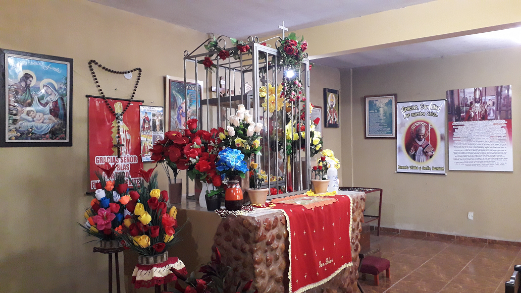
Inside there were a few more benches, varnished this time. It was however within a surprisingly plain building. There were posters up on the walls and various small icons on tables along one wall but apart from the icon of San Blas quite an empty space.
San Blas was the reason for the chapel existing and the icon itself dates from the first years of the 19th Century.
It stands encased in glass as the center point of the chapel. On a table in the center of the end wall it is kept. There it sits surrounded by artificial flowers of every colour. Beneath is the altar cloth and behind hangs an oversize set of rosary beads.
I had the chapel to myself so spent a few minutes in there with the icon before sitting outside on one of the benches for several more.
The chapel and its surroundings were tidy and clear of litter and having the luxury of being there outside festival week it was a very tranquil and relaxing place to stop off at for a while.
Now I know better how to get there a return visit will be far simpler.
A interesting read was hoping to enlarge the image you posted but my phone wouldn’t let me